
Flight Book
Create Flightbook creates a documentation of your bush trip in OpenXml-Document format. This can be opened and modified by many word-processing-apps like MS Word, Google Docs, OpenOffice, Apache OpenOffice and many more. The document should be compatible with ISO/IEC 29500, but no warranty – I don’t like to read 6000+ pages of documentations.
Template
Define a common template for all your bush trips with Format-Settings and predefined content like Header/Footer, Logo and so on. BushTripInjector is using Header 1-3 and Standard/Default paragraph settings.
BTI will start at the end of your template with fill in the content. Feel free to place your logo on top of the first page.
If you don’t set a template, BushTripInjector will use a internal default template but not your default template of your word-processing-app.
Header/Footer
With this flag you can tell BTI, if it should add a header and footer to the document for each page.
Format
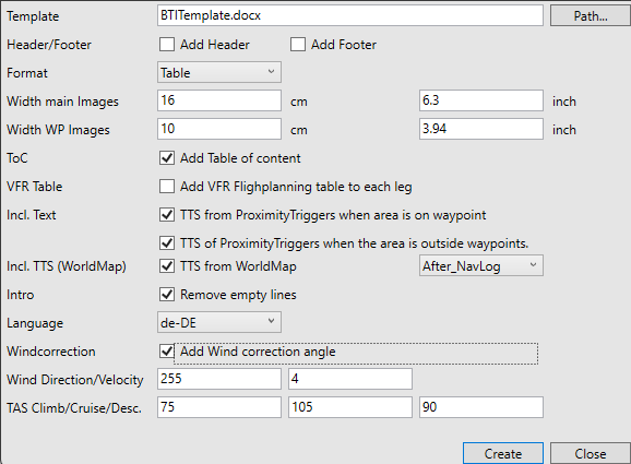
Select between a Freetext and Table Format. This affects the presentation of the images and the flight plan data at the beginning of the documentation for a waypoint. Freetext will add your waypoint text close to the flightplan information, Table will encapsulate the image and flight plan data into a table:
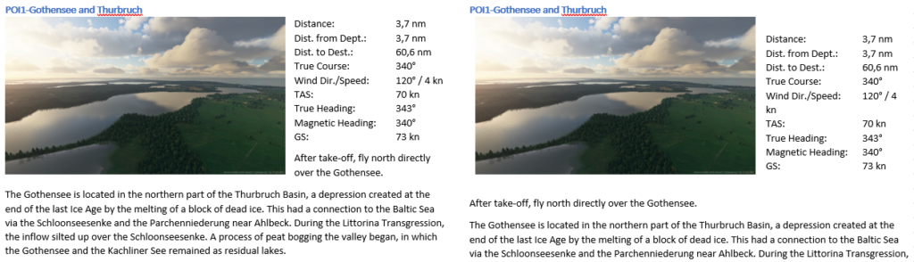
Image Sizes
Here you define the width of the images in your flight book. BushTripInjector will maintain the aspect ratio. Because of the different page formats, page margins and font sizes, you need to figure out the best size for you.
A good formula is:
- Usable page width for the main images and
- Usable page width without margin minus 5.5-6cm / 2.2-2.4″ (for flight info) for the waypoint images
ToC
With this flag you control if BushTripInjector adds a table of contents to your flight book.
VFR Table
With this flag you tell BushTripInjector, if a VFR flight planning table has to be added to each leg. There are two different flight planning tables available, depending on the setting of the Wind Parameters.
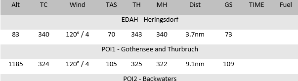
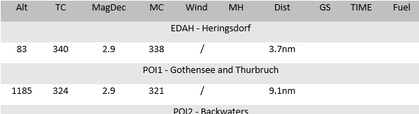
The VFR flight planning tables has these fields:
| ALT | Altitude from the flight plan. Source is Little Nav Map or BushTripInjector depending on the Adjust Altitude setting on Base Data. |
| TC | True Course The initial great circle course to reach the next waypoint without respect to wind and magnetic declination. |
| MagDec | Magnetic Declination The magnetic declination of the previous waypoint. This is calculated by BushTripInjector if it gets the data from the Sim on start-up. This should be the case if the community folder was detected correctly. If not, it is the magnetic declination of the last airport. (only when wind correction is off) |
| MC | Magnetic Course Pretty simple, True Course minus magnetic declination. (only when wind correction is off) |
| Wind | Current Wind situation. This is blank and can be filled by the user, if the wind correction parameter was off, else filled with your input. |
| TAS | True Airspeed The TAS you entered. (only when wind correction is on) |
| TH | True Heading This is the true heading. BushTripInjector calculates true course and the wind correction factors depending on your air speed. (only when wind correction is on) |
| MH | Magnetic Heading This is the heading you need to fly to reach the next waypoint. This includes all factors: Wind, TAS, Magnetic declination |
| Dist | Distance to next waypoint |
| GS | Ground Speed: Calculated by BushTripInjector from TAS, altitude from flightplan and wind correction. |
| TIME | To be filled by pilot |
| Fuel | To be filled by pilot |
Include Text
| TTS from ProximitiyTriggers when area is on waypoint | This will add any text from TTS from Event&Triggers Editor, when the TTS is assigned to a ProximityTrigger and one of the areas assigned to the trigger has the same coordinates as a waypoint. This text is added after the waypoint. |
| TTS of ProximitiyTriggers when the area is outside waypoints. | This will add any text from TTS from Event&Triggers Editor, when the TTS is assigned to a ProximityTrigger and one of the areas assigned to the trigger is near the flightpath after the waypoint. This text is added after the waypoint. |
| Incl. TTS (Worldmap) | This will add any text from TTS of WorldMap Rectangles. You can chose, if the text is added before or after the NavLog entry. |
Intro
Select whether BushTripInjector should remove empty lines from the intro text.
Language
The language in which the document should be created and which language table of your bush trips should be used for the creation.
Wind Parameters
- Wind Direction and Wind speed
- True Airspeed for climb, cruise and descent.