
Type your question
Flightplan
Section Table
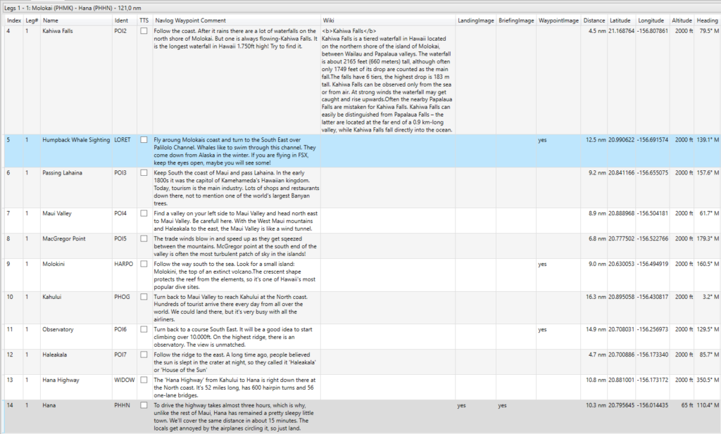
In the Leg-Selection-Box you are able to choose a specific leg only or all legs to be shown in the table.
| Column | Function | Source |
|---|---|---|
| Index | Number of Waypoint or Airport | BTI |
| Leg number | The number of the leg. | BTI |
| Name | Name of the Waypoint/Airport | LNM |
| Ident | Ident of the Waypoint/Airport. Adjusted from LNM to MSFS | BTI/LNM |
| Flags: TTS | Text-to-Speech: If you tick the box a text to speech will be read or Soundfile will be played when reaching the previous waypoint or leaving the previous airport. | User |
| Navlog Waypoint Comment | The Navlog-Entry in MSFS. This field needs to be defined in Little Navmap. It is “Flight Plan Position Remarks”. ATTENTION: As MSFS Bushtrips are working, you need to enter here how to REACH this Waypoint/Airport. Do not tell the user, how to fly away. | LNM |
| Wiki | If you have BTI search for text in the Wiki, found text will be entered her. If you click on the “Wiki”button, you can search for individual text of change the text BTI has chosen. If BTI has found more blocks of possible applicable text you can select one or more blocks. You can only remove the block, you cannot make any changes in the text. | User/Wiki |
Section Details
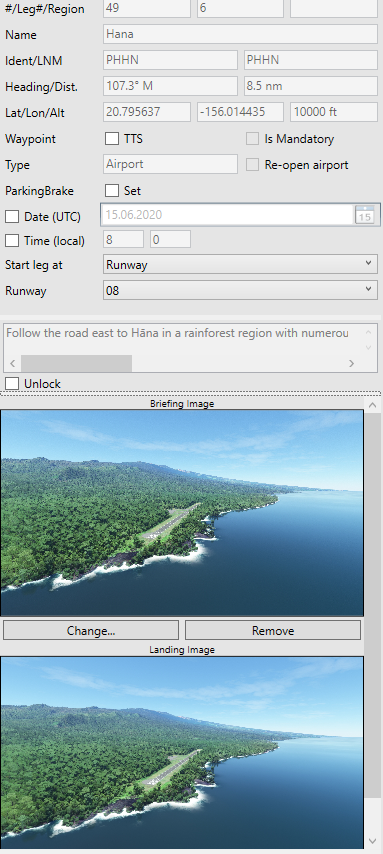
| Column | Function | Source |
|---|---|---|
| Index | Number of Waypoint Airport | BTI |
| Leg number | The number of the leg, where the Waypoint is. | BTI |
| Region | Region locator for MSFS, is also used for Leg-Identifier | BTI |
| Name | Name of the Waypoint/Airport | LNM |
| Ident | Ident of the Waypoint/Airport. Adjusted from LNM to MSFS | BTI/LNM |
| LNMIdent | Original Ident in your Little Nav Map File | LNM |
| Heading | The initial great circle magnetic heading from previous waypoint to reach this one (older BTI: to reach next one). | BTI |
| Distance | This is the great circle distance from previous waypoint (in older BTI version, to next waypoint) | BTI |
| Latitude/Longitude | The location of the waypoint in decimal coordinate system | LNM |
| Altitude | The flightplan altitude from Little Nav Map or the calculated altitude from BTI, if you adjusted the altitudes. | LNM/BTI |
| Waypoint: TTS | If you tick the box a text to speech will be read or Soundfile will be played when reaching the previous waypoint or leaving the previous airport. | User |
| Waypoint: Mandatory | If you tick the box the Way Point have to be touched when flying in a circle of ~0.5nm. If you miss the mandatory points the leg will not close | User |
| Type | Airport or User-Point | LNM/BTI |
| Parking Brake | If ticked, BTI will set the Parking Brake of your aircraft (if present) on the departure from this airport. It is only visible for departure airports and if the global Parking Brake Set on BaseData is unticked. | BTI |
| Date | If ticked, BTI will set the selected date when spawning into a mission from the activities menu or when you continue a bushtrip. | BTI |
| Time | If ticked, BTI will set the entered time when spawning into a mission from the activities menu or when you continue a bushtrip. Just keep in mind, the time is the local time. | BTI |
| Start Leg at | You can define, where the leg starts. Available values areDefaultRunwayParkingLocation | BTI |
| – Default | MSFS automatically selects where your aircraft will be positioned for the leg. In version 1.22.31 (SU12) this is the position of the aircraft when you finish the leg, if you continue the leg directly afterwards, or on a standard runway if you restart the leg or start the leg via the bush flight menu. The formula for the position on the runway is: center position of the runway - 0.5 * runway length. | MSFS |
| – Runway | When you select the runway, BTI positions the aircraft at the start of the leg at the threshold of the selected runway, regardless to how the leg is started. BushTripInjector naturally takes into account the heading of the runway and the magnetic deviation at the position. | BTI |
| – Parking | The same as for the runway, also applies to the parking position, if you select it. | BTI |
| – Location | If you want to position the aircraft at a certain position, you can insert the coordinates and choose the heading yourself. | BTI |
| Re-open Airport | If your flightplan contains a closed airport in MSFS, you are able to re-open the airport, so you can use it in your mission | User |
| Navlog Waypoint Comment | The Navlog-Entry in MSFS. This field needs to be defined in Little Navmap. It is “Flight Plan Position Remarks”. ATTENTION: As MSFS Bushtrips are working, you need to enter here how to REACH this Waypoint/Airport. Do not tell the user, how to fly away. | LNM/BTI |
| Unlock | By default, BushTripInjector takes the “Navlog Waypoint Comment” from Little Navmap’s “Flight Plan Position Remarks / Userpoint Remarks”. If you tick the box, you can define this inside of BushTripInjector and the entry from Little Navmap is ignored. Important: BTI assigned the text by the Ident. When you change the ident in LNM, BTI cannot assign them anymore! | User |
| Briefing Image | Enabled only for Destination Airports This image will be shown in MSFS, before you start the leg. With this action, you can select another briefing image or remove the current one for this Airport. You can mass-import/replace the images by drag and drop images to this sheet. see Drag’n’drop. | User |
| Landing Image | Enabled only for Destination Airports This image will be shown in the Nav-Log of MSFS on the destination airport entry With this action, you can select another landing image or remove the current one for this Airport. You can mass-import/replace the images by drag and drop images to this sheet. see Drag’n’drop. | User |
| Waypoint Image | Visible only for Waypoints This image will be shown in the Nav-Log of MSFS on this waypoint entry. With this action, you can select another image or remove the current one for this Waypoint. You can mass-import/replace the images by drag and drop images to this sheet. see Drag’n’drop. | User |
| Leg compl. TTS | Creates a TTS entry, which is read, just before the user completes a leg. | User |
| Show on Map | Shows the airport dimensions on world map for airports, or just a pushpin for waypoints. | User |
| Wiki | Runs the Wikipedia-functionality for this location. | User |
| Create Airport | Visible only for Waypoints. Here you can change the Waypoint to a self-defined airport with airport-generation module of BushTripInjector. | User |
| Modify Airport | Visible only for Airports created from Waypoints. Here you can change the self-defined airport with airport-generation module of BushTripInjector. | User |
| Remove Airport | Visible only for Airports created from Waypoints. This removes the self-designed airport and change the location back to a waypoint. | User |
Drag’n’drop
To mass replace images for waypoints or airports, you can drag and drop files from any folder on your PC into the flightplan sheet.
To assign the dropped images to an waypoint or airport, the following rules must meet:
- The image must be an Jpeg or an Png and have the file extention .jpg, .jpeg or .png.
- For Waypoints:
- The image filename starts with „WP“ or „POI“.
- The following number is the number of the Ident in BTI.
- I.e. „WP36 Mauna Kea.jpg“ is assigned to a waypoint with the ident „WP36“.
- For Airports:
- The image filename must not start with „WP“ or „POI“.
- A 3- or 4-digit ICAO code must be present in the filename. This ICAO code needs to be present in BTI’s internal airport database.
- Somewhere in the filename must be „BRIEF“ (for the briefing image) or „LAND“ (for the landing image)
- I.e. „Hana (PHHN) BRIEF.png“ will be assigned as briefing image for Hana-Airport in Maui, Hawaii.